Privately-Owned Public Open Space and Public Art
Privately-owned public open spaces (POPOS) are publicly accessible spaces in forms of plazas, terraces, atriums, small parks, and even snippets which are provided and maintained by private developers.
San Francisco has a 1% Art Program that requires all projects involving new building, or the addition of 25,000 square feet or more in the Downtown and nearby neighborhoods, provide public art equal to at least 1% of the total construction cost. This program was established by the 1985 Downtown Plan and is governed by Section 429 of the Planning Code.
Since May 2012, some projects may choose to dedicate a portion of their 1% Art requirement to the City's Public Art Trust. To read more about the requirements, and the Public Art Trust, please read the Public Art Requirement Fact Sheet.
In 2013, Section 429 of the Planning Code was amended to expand the public art requirement to all non-residential projects that involve a new building or addition in excess of 25,000 square feet in 15 zoning districts, concentrated in sections north of downtown along the waterfront, most of the South of Market, Dogpatch, and parts of the Mission District. Read a summary of the current requirements for Public Art.
The 1985 Downtown Plan
In San Francisco, POPOS mostly appear in the Downtown office district area. Prior to 1985, developers provided POPOS under three general circumstances: voluntarily, in exchange for a density bonus, or as a condition of approval. The 1985 Downtown Plan created the first systemic requirements for developers to provide publicly accessible open space as a part of projects in C-3 Districts. The goal was to "provide in the downtown quality open space in sufficient quantity and variety to meet the needs of downtown workers, residents and visitors." (See Planning Code Section 138 for regulations). Since then, project sponsors for residential projects may provide POPOS instead of their required open spaces in the Downtown Residential (DTR) and Eastern Neighborhoods (Section 135 of the Planning Code).
Today's Downtown Gallery
More than 25 years since the adoption of the Downtown Plan, downtown has seen the growth of an extensive outdoor gallery that enriches the environment for workers and tourists alike. The spirit of the 1% for Art requirement is to ensure that the public has access to high-quality and variety in art. To help catalog the Downtown public art gallery and to increase public access to this art, the Planning Department has created a map displaying the locations and images of public art in the downtown district (see Map tab), and a printable guide available for download: Today's Downtown Gallery.
About the Downtown Plan
The groundbreaking "Downtown Plan," adopted in 1985, was developed under the fundamental assumption that significant employment and office development growth would occur. New commercial development would provide new revenue sources to cover a portion of the costs of necessary urban service improvements. Specific programs were created to satisfy needs for additional housing, transit, childcare, open space, and art.
- Ordinance Number 228-12 Planning Code Amendment – Signage Requirements for Privately-Owned Public Open Space: Read a summary of this new law.
- Ordinance 62-12 Public Art Fee and Public Artwork Trust Fund: Read a summary of this new law.
- Today's Downtown Gallery: Public artwork created by the 1% for Public Art program codified in the Planning Code
- Downtown Area Plan
- Fine Art Guidelines
- 25 Years Downtown Plan Monitoring Report
- San Francisco Arts Commission
- Download Map Data
- Zoning Administrator Bulletin No. 8
- POPOS Signage Design Toolkit
Fine Arts Guidelines
The "Fine Arts Guidelines", approved in 1986, clarifies how this requirement should be met. This document stresses that the goal of the Downtown Art program is to achieve a more vital and interesting downtown while safeguarding the many subjective choices which can be made in the process. The Guidelines specify the process and the roles that developers, architects and artist play, emphasizing the many avenues by which the 1% expenditure can be creatively made.
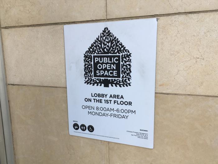
POPOS Signage
POPOS provide a great value to workers, residents and visitors of the Downtown. This value is lost if the spaces are not readily identifiable and accessible. In 2012 the City approved legislation that upgraded the signage controls, requiring additional information be provided about the POPOS and regulating the size, design, and content of the plaques. A new well-designed logo brands these POPOS to help the public understand the individual spaces as part of a larger network. Installing the plaque at every pedestrian entrance will direct the public to interior and rooftop spaces.
Please see Zoning Administrator Bulletin No. 8 for specific dimension and design guidelines for the POPOS signage.
To download the POPOS Signage Toolkit for the template, click here to download (.zip file).
Read a summary of the current requirements for POPOS Signage.
Enforcement
The Planning Department's Zoning and Compliance Division reviews POPOS sites for compliance that were approved subject to the requirements of the Downtown Plan (darker green icons on the map). Property owners of POPOS that are not in compliance with signage AND other Conditions of Approval related to open space requirements will be notified of complaints.
As a result of recent changes to law and the related enforcement efforts, some existing spaces received new signage, such as this POPOS located at 1 Kearny Street (approved in 2006):
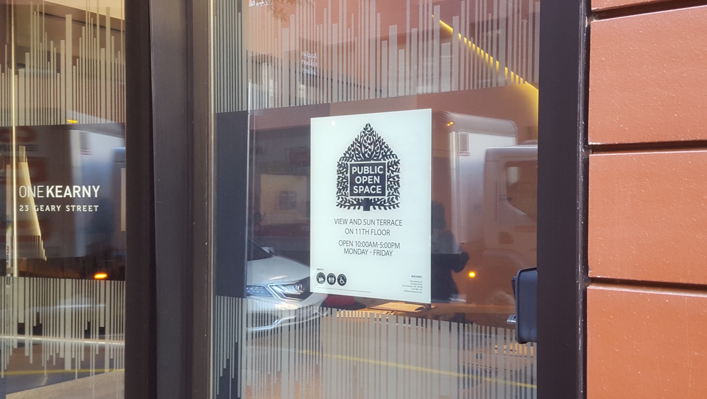
POPOS that are not in compliance will be subject to further enforcement action that may result in penalties per Section 176 of the Planning Code. If you believe that one of the mapped locations for public art or POPOS is out of compliance, you can get information on filing a complaint here.
POPOS and Public Art
In the summers of 2011 and 2012, for the first time, Planning Department staff visited all POPOS and required Public Artworks and created a comprehensive database. Since then, staff have routinely updated the database to show the latest built and public art. The resulting map below is intended to raise awareness of such spaces and works of art that are available to the public. This map displays POPOS and Public Artworks in San Francisco.
To avoid selection error, please zoom in to the area of interest in order to separate overlapping icons.
Map Instructions: Click on any POPOS to get more information. Type an address and click the magnifying glass to move the map to that address. POPOS with certain features can be selected in this map. When "Food Available" is marked, only POPOS that have Food available directly adjacent to the space will show. When two or more features are selected at the same time, only POPOS that include ALL those features will remain on the map.